






Dam Thi Nai through the lens of science and art
WVR - The exhibition “Dam Thi Nai: A Natural Heritage Worth Preserving” is the result of collaboration between French and Vietnamese scientists and artists within the framework of the “Living with Rivers” (Vivre avec les Fleuves) project, supported by the French Embassy and the French Institute in Vietnam.
Latest
The exhibition is open from September 26, 2026, to March 25, 2027, at the Science and Innovation Discovery Center - ExploraScience Quy Nhon, introducing the public to the natural features, ecological values, and the connection between the lagoon and rivers and the sea through a scientific perspective combined with photography, illustration, and documentary film.
An Ecosystem Linked to Rivers and the Sea
Located near Quy Nhon (Gia Lai province), Dam Thi Nai is the second-largest coastal lagoon in central Vietnam, covering an area of about 50 km². The lagoon connects with the Kon River, Ha Thanh River, and opens to the East Sea, forming a system influenced by tides, river flows, climate, and human activities.
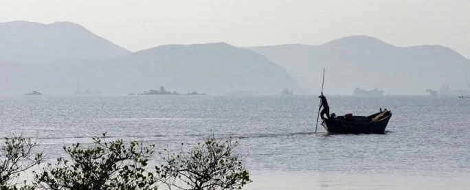 |
| Located near Quy Nhon, Dam Thi Nai is the second-largest coastal lagoon in central Vietnam, covering an area of about 50 km². (Source: Organizing Committee) |
The exhibition is structured around four themes, from the beauty and diversity of the landscape, the functioning of the lagoon system, to its values for the community and natural environment. The content also addresses the pressures the lagoon faces, emphasizing the role of scientific knowledge and long-term monitoring in management and conservation.
Dam Thi Nai provides numerous benefits to the local community, especially from fishing and aquaculture, while also being home to many ecosystems crucial for coastal biodiversity. The lagoon's operation depends on tides, freshwater, and sediment from rivers, as well as seasonal changes due to the monsoon regime.
According to the exhibition's content, changes in the area surrounding the lagoon and throughout the entire basin, such as urbanization, infrastructure development, agricultural production, aquaculture, or flow regulation, can impact the amount of water and sediment entering the lagoon, water quality, and the exchange process between the lagoon and the sea.
Three Perspectives to Monitor Changes
Since 2025, scientists from the French Institute for Development Research (IRD), University of Science and Technology of Hanoi (USTH), along with Vietnamese and French partners, have conducted about 10 surveys in different seasons across the entire Dam Thi Nai.
Monitoring results indicate this is a highly dynamic environment. Within a single day, tides can cause water levels to change by about 0.5-2 meters depending on the period. The average water level can also vary by about 50-60 cm seasonally.
During the rainy season, large amounts of water from rivers flow into the lagoon, reducing salinity, increasing turbidity, and altering water composition. Conversely, the dry season with reduced river flow allows seawater to penetrate deeper, increasing salinity and making the water clearer.
Studies on organic matter and certain pollutants, including PFAS and trace metals, show different distributions by season and area. Currently, results do not indicate widespread water quality degradation. Continued monitoring helps distinguish natural fluctuations of the lagoon from human activity impacts.
In addition to field surveys, the research team uses data from the European Sentinel-3 satellite and the SWOT satellite - a French-American collaboration program by CNES and NASA. Direct measurements at the lagoon are used to verify satellite information, from water levels to certain water quality parameters.
Numerical modeling is also used to simulate water circulation and the exchange process between rivers, the lagoon, and the ocean. This tool allows studying the water retention time in the lagoon and testing scenarios related to river flow regulation, planning, development of the lagoon's surrounding area, and the impacts of climate change, including sea level rise.
The exhibition features photographs by Nicolas Cornet, Vu Khoi Nguyen, and Alexis Chaigneau, illustrations by Paul Rey, and the short documentary “Mua Thi Nai” by Solène Ouillon. Through the combination of science and art, the public gains a new approach to a coastal ecosystem, from current happenings to future monitoring and conservation challenges.
Tags: