Vietnamese seas: Irreplaceable position resources and amenities
Besides living and non-living resources, Vietnam's seas have irreplaceable position resources and amenities.
Latest
 |
| Vietnam's seas have irreplaceable position resources and amenities. (Source: Cong Thuong Magazine) |
Vietnam's marine economic strategy in 2030 with a vision to 2045 clearly states the general goal to make our country a strong coastal State, enriching from maritime areas, firmly ensuring national sovereignty, sovereign rights and jurisdictions, making important contributions to industrialization, and modernization process. Vietnam's maritime strategy aligns with the trend of "moving toward the sea" that the 1982 United Nations Convention on the Law of the Sea (UNCLOS) has laid the foundation.
Besides living and non-living resources, Vietnam's seas have irreplaceable position resources and amenities.
Position resources
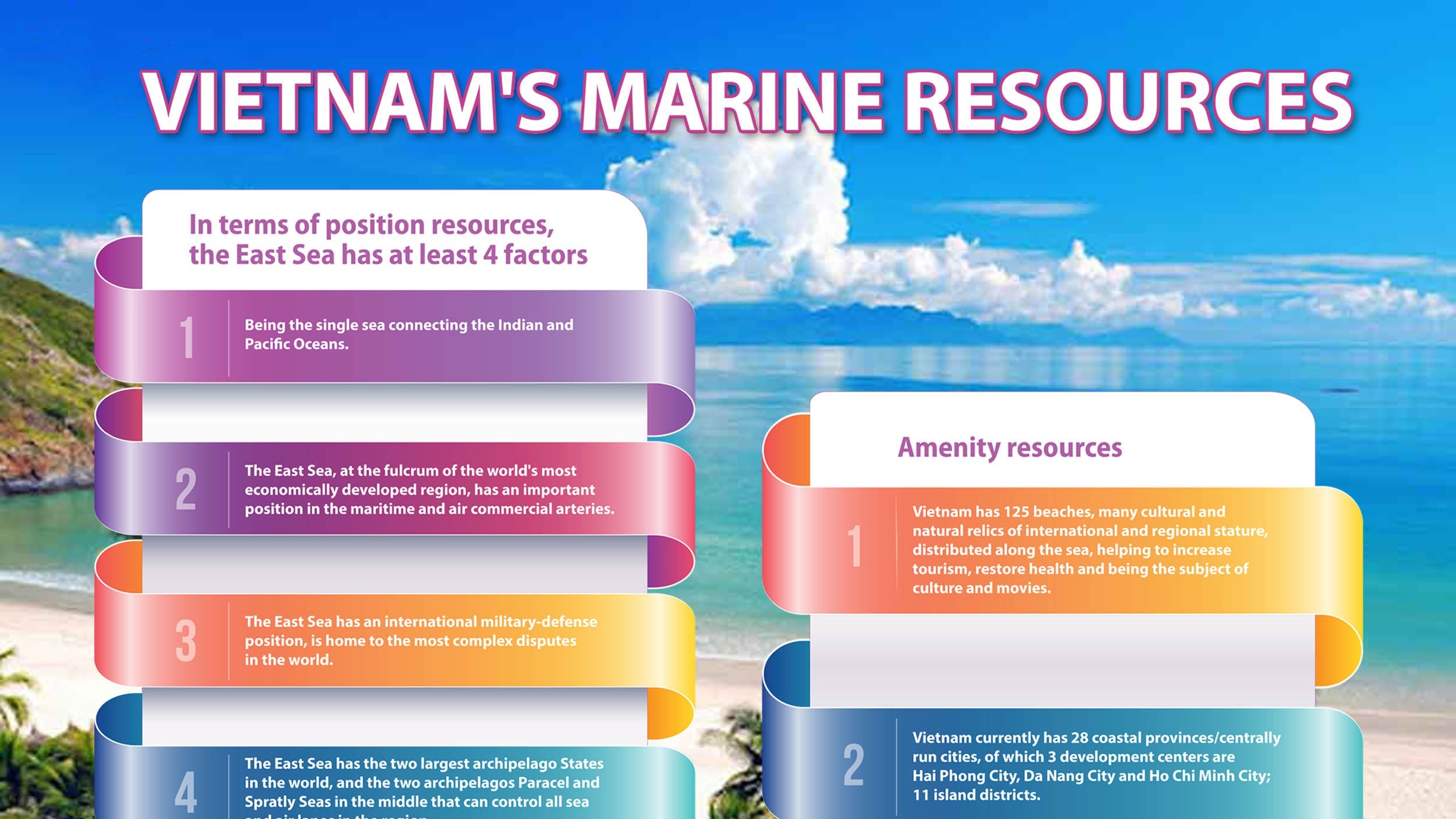
In terms of position resources, the East Sea has at least 4 factors.
Firstly, being the single sea connecting the Indian and Pacific Oceans, the East Sea is a place of intersection and competition of many great cultures (Chinese, Indian, Western), and many great powers in history. The Open Indo-Pacific Initiative or One Belt, One Road Strategy extends through the East Sea.
Second, the East Sea, at the fulcrum of the world's most economically developed region, has an important position in the maritime and air commercial arteries between the Indian and Pacific Oceans, between Europe and the Middle East and China, Japan, South Korea and other countries in the region. 5 of 10 largest sea lanes in the world, and more than half of the world's oil and commercial ships pass through the East Sea, making it the second most trafficked after the Mediterranean. About 80 percent of Japan's oil imports (from the Middle East and Southeast Asia) 29 of China's 39 maritime routes and about 60 percent of imports and exports are now transported through the East Sea. On average, 250 to 300 U.S. ships of all kinds pass through the East Sea every day, including 15 to 20 percent of large vessels over 30,000 tons.
Third, the East Sea has an international military-defense position, is home to the most complex disputes in the world (Spratly Islands and Taiwan Strait) that possess the potential to lead to World War Three if not managed well.
Fourth, the East Sea has the two largest archipelago States in the world (Indonesia and the Philippines), and the two archipelagos Paracel and Spratly Seas in the middle that can control all sea and air lanes in the region.
Vietnam's sea stretches across 16 parallels, which not only has biodiversity value but also facilitates the expansion of the country's living space to three times that of land (nearly 1 million kilometers of sea), according to the principle of land dominating the sea and the provisions of UNCLOS 1982. Vietnam's maritime index (coastline/land area) of 0.01 is among the 30 countries with the highest index, higher than Thailand (0.007) and nearly to Malaysia and higher than the world average of 0.006.
Vietnam has 2773 coastal islands, two Paracel and Spratly archipelagos and a coastal land strip forming a multi-layered defense line near and far from the shore, creating favorable conditions for deploying the people's defense and security posture at sea and ensuring early and from afar national defense, The system of offshore islands forms a baseline used to calculate the width of the territorial sea, exclusive economic zone and continental shelf. Vietnam and Malaysia are two coastal states that met the requirements and have exercised the right to extend the outer limit of the continental shelf.
Its position on the coast of the East Sea also allows Vietnam to help landlocked and geographically disadvantaged States (Lao and Campuchia) exercise their right to transit to the sea, contributing to strengthening ASEAN's centrality.
Amenity resources
In terms of amenities, Vietnam has 125 beaches, many cultural and natural relics of international and regional stature, distributed along the sea, helping to increase tourism, restore health and being the subject of culture and movies. In the coastal area, there are eight key tourist areas of the country including Ha Long Bay, Do Son, Cat Ba, Hue, Da Nang, Nha Trang, Ho Chi Minh City, Vung Tau, Con Dao, including two world natural heritage sites, Ha Long Bay and Phong Nha - Ke Bang National Park; three world cultural heritage sites: Hue ancient capital, Hoi An ancient city and My Son relics; National Parks with seas such as Cat Ba, Bai Tu Long, Con Dao and Phu Quoc, and national parks in coastal provinces such as Xuan Thuy (Nam Dinh), Cuc Phuong (Ninh Binh), Ben En (Thanh Hoa), Pu Mat (Nghe An), Vu Quang (Ha Tinh), Bach Ma (Thua Thien - Hue), Nui Chua (Ninh Thuan), U Minh Thuong (Kien Giang); 22/55 nature reserves such as Yen Tu in Quang Ninh, Son Tra Peninsula, Ba Na in Da Nang, Cham Island in Quang Nam, Binh Chau - Phuoc Buu in Ba Ria - Vung Tau; bird yards in Ca Mau, Kien Giang; 915/2,509 historical and cultural relics ranked by the Ministry of Culture, Sports and Tourism.
 |
| Vietnam currently has 28 coastal provinces/centrally run cities. (Source: baodantoc) |
Vietnam currently has 28 coastal provinces/centrally run cities, of which 3 development centers are Hai Phong City, Da Nang City and Ho Chi Minh City; 11 island districts of Co To, Van Don (Quang Ninh), Cat Hai, Bach Long Vi (Hai Phong), Con Co (Quang Tri), Hoang Sa (Quang Ngai), Ly Son (Quang Nam), Truong Sa (Khanh Hoa), Phu Quy (Binh Thuan), Con Dao (Ba Ria - Vung Tau), Kien Hai (Kien Giang), 1 island city (Phu Quoc). In 2020, the GDP of 28 coastal provinces reached VND 4,040.7 trillion, accounting for 50.1% of the country's GDP, the GDP per capita of coastal provinces in 2020 atteint VND 84.4 million, compared to the national average of VND 82.7 million.
The 9 provinces with higher growth rates are the ones with the advantages of marine location and economy (Hai Phong, 10.4%/year), in tourism (Quang Ninh, 8.4%/year) and coastal localities that strongly attract FDI. The export value of coastal provinces in 2020 only accounted for 34.9% of the total export value of the country. This ratio is not commensurate with the population size and GDP of coastal areas (above or below 50%). Coastal provinces are not really superior in economic development compared to inland regions. Vietnam still has a lot of untapped potential to have a true marine economy.
Vietnam's marine economic strategy in 2030 with a vision to 2045 has changed the perspective and priority of marine economic development, paying attention to exploiting positional resources and amenities rather than living and non-living resources. The strategy specifies priorities for the development of tourism and marine services, maritime economy, oil and gas economy and other marine mineral resources, marine aquaculture and fisheries, coastal industry, renewable energy and new marine economic sectors, development of marine and coastal infrastructure, economic development of island districts, improvement of the economic, cultural and social life of coastal residents, attachment to the sea, friendliness to the sea, development of marine science and technology, development of marine human resources, disaster response, adaptation to climate change; safeguarding national defense, security, promoting foreign affairs and international cooperation.
Tags: