Work begins on century high altitude marker to serve urban planning
Latest
 |
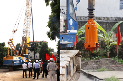
| Work begins on century century-high altitude marker in Soc Son, Hanoi (Photo: VNA). |
Under the project, 99 high-altitude markers will be built in 40 provinces and cities, with the aim of ensuring the accurate and consistent determination of high altitudes at every point and every location in the country.
Talking more about the significance of implementing the above project, the representative of the Ministry of Natural Resources and Environment said that the elevation system is a component in the system of national basic geodetic networks, playing a key role in Building a national geospatial data infrastructure.
The altitude system is very important in studying the topography of the territory and territorial waters to serve socio-economic development, ensure national defense and security, prevent natural disasters and floods, and respond to change. climate.
Therefore, determining the accuracy and consistency of elevation for all locations on the mainland and on the islands is always the top requirement to be achieved by a modern elevation system. In Vietnam, the elevation network was built in 1959 and has gone through many stages of construction measurement.
The most recent construction period was from 2001 to 2008, during which the class I and class II elevation lines were re-measured.
Work on the century-high altitude marker is expected to be completed on March 12, 2025. Once operational, it will provide accurate high altitudes for urban planning and development as well as the construction of auxiliary works such as traffic systems, drainages, and pipeline systems, thus helping to increase the effectiveness of flood prevention and arrange planning in accordance with the terrain.


